
It´was some years ago, surely in 2012 after discovering Thomas Gould´s map had been digitalized in the Internet, when I decided to put some order to all the information I was acquiring while reading dozens of books related with the Franklin expedition.
The idea of making a map for my personal use had then much more sense after I read Unravelling the Franklin Mistery and Strangers among us both of Dave Woodman. Two superb books which tried to understand and guess what happened to the crews of HMS Erebus and Terror once they "deserted" the ships. The books compile, describe and try to interpret a good number of objects found in the desolated ground of King William island and also deals with the wide variety of Inuit testimonies told to the Franklin searchers of all times and which have demonstrated in time they were very accurate.
I have to recognise that after reading those two master pieces, the original narratives of Charles Francis Hall, Schwatcka, Russell´s Potter book "Finding Franklin" and a good number of articles and many other books, I was still lost in the apparently simple geography of King William Island and surroundings and have sometimes problems to understand that a particular cairn was different to other, and where were located all those places that Woodman was speaking about. I had to do something not to get lost together with the Franklin men.
Well, I am not a researcher nor a historian, just an amateur enthusiast of Polar exploration, but I consider myself good at gathering things, and that´s exactly what I did here.
Logically, my starting point was the map of King William island made by Commander Thomas Gould. As I mentioned above, The Library and archives of Canada started a project on which they digitalized Admiralty charts of Canadian waters. Among the digitalized maps was Gould´s map of King William Island.
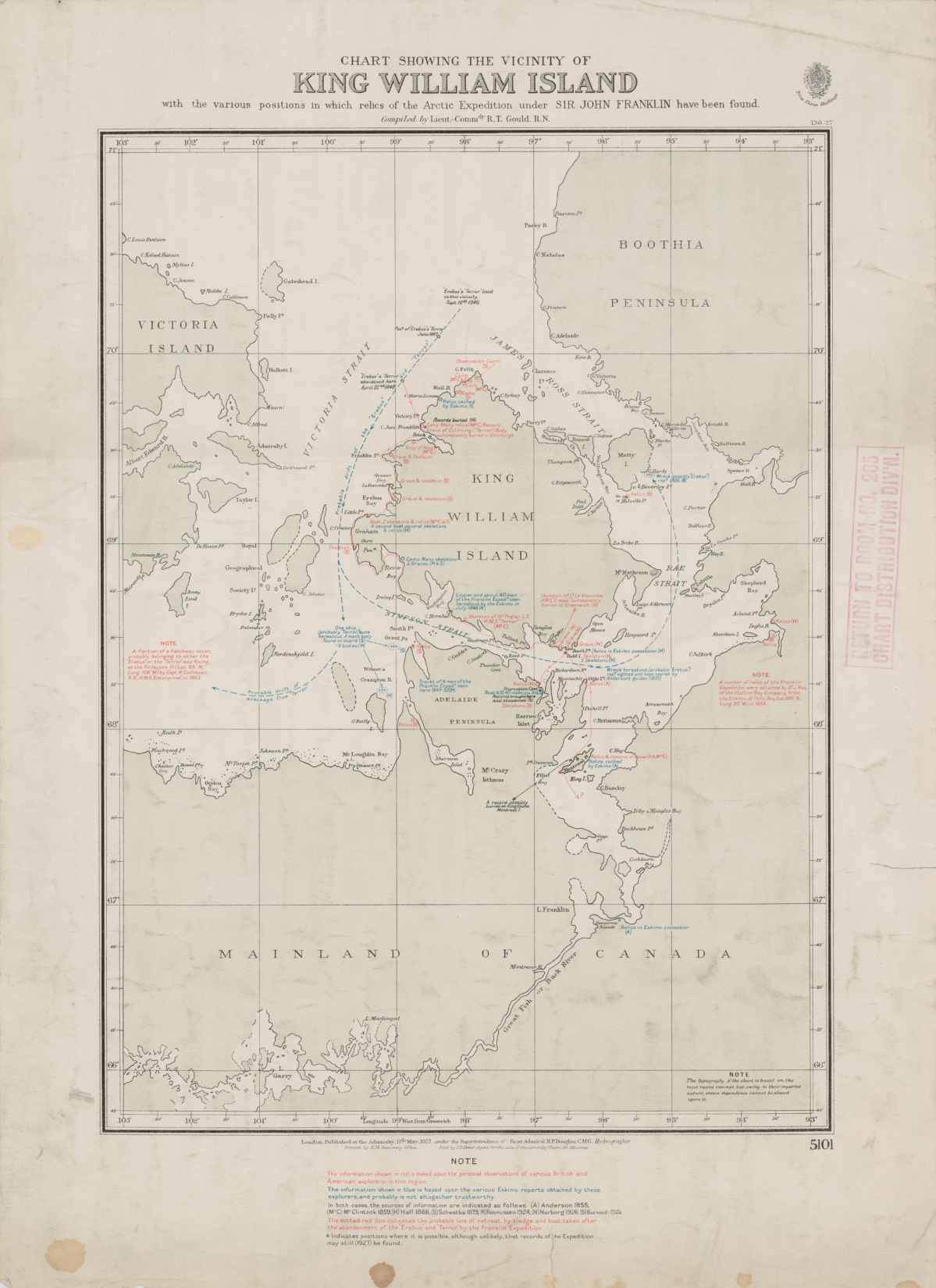
That map published in 1927, showed everything which had been found in the area till the moment by the searching expeditions of McClintock, Charles Francis Hall, Schwatcka, Rasmussen, Burwash etc. Gould painted in blue the Inuit testimonies and in red the actual relics found. According to Russell, Gould´s map apparently was made at the request of Burwash.

There were other maps like the one which shows Klutschak findings made in 1880, but any had ever put together all the information available at the moment. Burwash had a very good idea. Soon I realised we, Franklinites, needed a more practical tool than a single and static map, no matter how useful and amazing this can be, as Gould map is. A map which could allow us to identify places, edit wrong coordinates, add descriptions and links and add new findings, etc, etc. Don´t forget that searching parties are still visiting King William island and every year it passes, more sophisticated and accurate are the devices used in the search and research. It is foreseable that new items will appear, this time precisely located by GPSs, which modern researchers are currently carrying with them and not roughly and approximately as the former searchers did with the means of their time.
I needed as water in the desert a tool which could be updated instantly and which could place with precission of seconds of latitude and longitude every item found in that barren ground.
I needed as water in the desert a tool which could be updated instantly and which could place with precission of seconds of latitude and longitude every item found in that barren ground.
The more accurate tha map was evolving the more I realised how useful it could be for others apart of me. So, the past year, when I learnt how to share Google maps in my blog, (before I just shared a .kml file with those who had shown some interest or in facebook groups) I decided to make it public for everybody. Since then, many people have contributed to make it more precise and accurate, however, I am sure there are still mistakes which must be mended. Unfortunately, many of the places are not precisely located, it will take time to correct all those wrong points one by one, and to remove repeated cairns, etc, etc. Olivier Benoit and me know well the mess of Cairns I had in Cape Felix.
The map has evolved since its beginning of a single mass of yellow pins, which are the ones used by default by Google Earth, to a more friendly look on which I have used the wider range of pins available in Google maps. The map, of course includes a layer with the names of the geographical places, without which I at least would be lost, and a layer of Inuit Testimonies, like those blue points marked by Gould, which is still at work.
I made the map after reading many Franklin related books. I think it is time to reread many of those jewells, specially Woodman´s ones and to fill the gaps which still does exist. There must be dozens of relics still to place and cairns to locate, not necessarily built by the Franklin expedition but by the searchers and by the Inuit. I hope that with time the map will be properly finished and that it could be an useful tool for researches and not a mere curiosity made by an enthusiast. To this day the map has been visited 2.250 visits, I am more than proud of that number, that is enough reward for me.
I couldn´t end this post without giving thanks specially to Randall Oxczevski, who is scanning with zeal from his armchair every single dot and pixel of King William island and vecinity through sattellite images. His contribution to make this map more perfect is unvaluable. I would like also to thank to Russell Potter, whose posts of Visions of the North put essential context and color to many of the pins you will find in the map. Also thanks to Russ Taichman, Peter Carney, Olivier Hubert-Benoit who have made valuable contributions and has made me add some relics and graves which I had missed or didn´t know.
I couldn´t end this post without giving thanks specially to Randall Oxczevski, who is scanning with zeal from his armchair every single dot and pixel of King William island and vecinity through sattellite images. His contribution to make this map more perfect is unvaluable. I would like also to thank to Russell Potter, whose posts of Visions of the North put essential context and color to many of the pins you will find in the map. Also thanks to Russ Taichman, Peter Carney, Olivier Hubert-Benoit who have made valuable contributions and has made me add some relics and graves which I had missed or didn´t know.
I hope you will enjoy it my amigas y amigos !
He caído en este blogo buscando información sobre el clima glacial, el de las glaciaciones, porque yo tambien escribo pero no sobre exploraciones polares. Me he tirado hora y media leyendo los posts... ¡Qué estupendo blog! Me ha encantado la información, y sobre todo la pasión por el asunto. Solo había leído sobre Franklin "El descubrimiento de la lentitud" de Sten Nadolny, que me gustó mucho. Pero sí que he picoteado cosas sobre la expedición de Shackleton, al tener la... casualidad de contar entre mis amistades en Irlanda a Mrs. L. Ferguson, neé Shackleton, de Dublín. Enhorabuena por el blog, enlazaré al mío alguna de sus historias.
ResponderEliminarMuchas gracias Carmen, perdona por no haber contestado antes. Por alguna razón ya no recibo avisos en el correo sobre los comentarios. Encantado de conocerte y me alegro de que te guste. Yo por mi parte estoy escribiendo algo sobre Franklin y el pasaje del Noroeste que espero terminar algún día, hay mucho de lo que hablar y no he aprendido todavía a sacrificar parte del contenido al que quiero darle visibilidad, en fin... es un largo proceso.
ResponderEliminarAndres, amigo
ResponderEliminarI just came across this wonderful project of yours. A massive undertaking that will surely assist everyone who struggles with collating the geography/relics/testimony concerning the Franklin expedition. I have some GPS positions that you might need, as well as some testimony that could be attached. Please email me if you are interested.
Also, of course, thank you for your kindness in reference to my books. Hopefully the current Parks Canada work will soon render them obsolete!
Cheers,
Dave
Hi Dave, it is a pleasure to read you again here in my humble site. I am delighted that you like this project. It has taken me some time to place all those Franklin relics, graves, cairns and so on though there must be many which I haven´t placed yet. The next step is rereading thoroughly your two books and see if there is still something missing in the map I must add.
ResponderEliminarI don´t think your books will be obsolete ever. I share the hope many have that Parks Canada will find something which could help us to link those "windows in time" which the Inuit opened for us, but I am quite sure that whatever thing they find won´t finish the puzzle completely, there will be always room for speculation.
Your work was, and still is, amazing. One of the finest job about the matter I have ever read, a reference for many which is still a valid text-book for both, scholars and amateurs after 27 years.
I don´t think I have your email address Dave, mine is aparedessal@yahoo.es It will be wonderful to pinpoint with precision all the things were found.