
In the northwest coast of the now mythical King William island, not far from the northernmost corner of the triangle shape wich it forms, a two meters high cairn was built the 29th may 1830 by James Clark Ross. That was the first time this island was visited by explorers. The next visitors would be Thomas Simpson and Warren Dease who, in 1839, would build another cairn in the south coast.
Ross, accompanied by some men and eight dogs, left on may 1830 their ship Victory in Felix Harbour to lead a sledge party which intention was to ascertain if there was any passage connecting Prince Regent Inlet with Point Turnagain. That was the furthest point reached by John Franklin in the north coast of the American continent during his expedition of 1819-21.
The party crossed Boothia peninsula and the channel which separates it from King William Island, James Ross strait, to end landing in its northeast shore. They hadn´t found the navigable connection they were looking for, but had discovered a new piece of land in the very heart of the arctic archipielago.
Ross´s reflections, right after landing on the island which was destined to be remembered forever as the scenary of the biggest polar tragedy of all times, look to me somehow premonitory:
"No one will be surprised to hear how often during all these years we have formed the idle wish that men could live without food; a wish, idle and nonsensical as we felt it, that has ever intruding, since the necessity of eating was the ever-recurring obstacle to all our endeavours"
If these "idle and nonsensical" wishes had become true, Franklin´s expedition´s fate would have been a very different one.
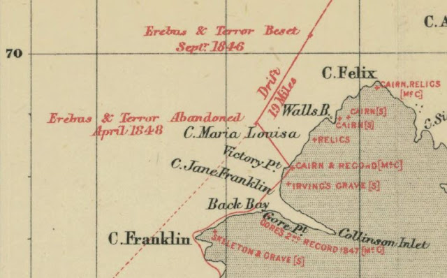
Once in these new land, they walked northwestward and reached Cape Felix, the northern tip of King William Island. From there, they carried out to the southwest following its shores. Ross was happy to see how now the coastline was leading him towards his target, Point Turnagain but Ross´s provisions were scarce. They were meant to last just twenty one days, a great contrast with the provisions carried by fututre parties which could travel for as long as three months, so the expedition had came to its end.
Thomas Abernethy and James Ross separated from the party and continued southward some miles more till they decided to stop north of Back´s bay. This was the place where they decided to turn around and where they built the cairn which would become years after the recipient of the only (*) written message coming from the Franklin expedition. Ross describes the moment this way:
"We now therefore unfurled our flag for the usual ceremony, and took possession of what we saw as far as the distant point, while that on which we stood was named Victory point; being the " ne plus ultra " of our labour, as it afterwards proved, while it will remain a standing record of the exertions of that ship's crew. The point to the south-west was also named Cape Franklin: and if that be a name which has now been conferred on more places than one, these honours, not in fact very solid when so widely shared, are beyond all thought less than the merits of that oflicer deserve.
On Victory point we erected a cairn of stones six feet high, and we enclosed in it a canister containing a brief account of the proceedings of the expedition since its departure from England. Such has been the custom, and to that it was our business to conform ; though I must say, that we did not entertain the most remote hope that our little history would ever meet an European's eye, even had it escaped the accident of falling into the hands of the Esquimaux.
Yet we should have gone about our work with something like hope, if not confidence, had we then known that we were reputed as lost men, if even still alive, and that our ancient and tried friend Back was about to seek for us, and to restore us once more to society and home. And if it is not impossible that the course of his present investigations from Cape Turnagain east-ward may lead him to this very spot, that he may find the record and proof of our own "turnagain," we have known what it is for the wanderer in these solitudes to alight upon such traces of friends and of home, and can almost envy him the imagined happiness; while we shall rejoice to hear that he has done that in which we failed, and perhaps not less than if we had ourselves succeeded in completing this long pursued and perilous work."
The Victory point cairn was born. It was elegantly crowned with the Union Jack and stood proud looking defiantly to the icy waters which laid to its west. "More explorers will come to put an end to this war", it looked to be saying..., and they actually did, but to fight a hopeless battle instead.
As we have read above, Ross seemed to have some sort of prophetic powers. Apart from the aforementioned appropiated reflection about the ´so human´ necessity of food (specially in this barren lands), he named the farthest piece of land at sight as Cape Franklin. Apparently, after being christened, the cape started to intone an inaudible syren´s chant which attracted the Franklin expedition to its perdition. The crews from Erebus and Terror landed close to this point in april of 1848. Their target now wasn´t to continue the exploration, but to run towards safety in a desperate race to survive.
It would had been a coincidence that Franklin, who died in june of 1847, had been buried in the cape which bears his name. A coincidence similar to that of the watery grave, Terror bay, in which was found HMS Terror shipwreck not long time ago. But however prophetical Ross could be, he was wrong this time about the fate of the record he left in the cairn. He failed to foreseen that the paper he had left would be indeed taken by european hands seventeen years later in 1847, or at least that is what I think it should have happened.
It was by chance, while consulting the detailed map of John Ross narrative of his voyage of 1829-33, that I found this interesting drawing of the landscape as it was seen from Victory point placed in the down left corner upside down.
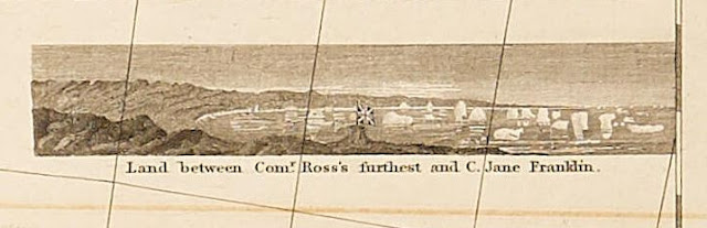

I am not completely sure if I had seen this before. The drawing sounds very familiar to me, but I can´t remember where or when I have seen this. The sight of the Union Jack waving happily at Victory point years before it would become the monument of a tragedy looks very dramatic to me. It was built to take possesion of a land and also to indicate from where future expeditions should resume the exploration of the Northwest passage but now it is only reminded as the bearer of bad news.
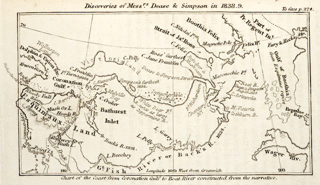
The next visitors to this region, Simpson and Dease, mentioned above, drew in the maps part of the south coast of the island and discovered the strait which separates the mainland from King William island.

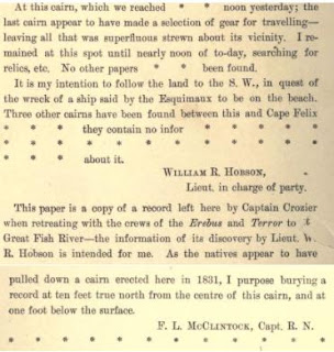
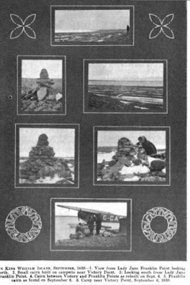

Hobson found Crozier's cairn near the beach where the crews had come ashore after abandoning the ships. He left it standing after finding the canister with the paper that had been left by Gore at Ross's Victory Point. When McClintock reached the cairn days later, he took it down to the ground hoping to find other messages in it, but there were none. He did not say that he rebuilt it. It is still just a patch of stones strewn over the ground. He carried on to Cape Felix where he specifically noted that he rebuilt a different cairn that had been dismantled by Lt. Hobson. The large cairn that still stands at Crozier's Landing was built two decades later by members of the Schwatka Expedition. When the Schwatka Expedition reached the site of the Franklin Camp a few miles south of Ross's Victory Point, there were no standing cairns. They left one, a signpost, atop a gravel ridge above the beach to indicate the location of Irving's grave. Years later, Burwash, who thought the Schwatka cairn was Crozier's, took it down and rebuilt it, as did Larsen several years later. No messages were found in or under it and no grave, just a bit of wool cloth. The cairn at Ross's Victory Point, "~four miles north" of where the crews came ashore (Crozier's Landing), is still visible, though it too has been largely demolished. That is my understanding of the chronology.
ResponderEliminarThanks Randall!
ResponderEliminarI think I am mixing cairns. From what you say, and from what Franklin´s note says, we should assume that the one on which the note was found is a different cairn from the one in Victory point. I have been always confused about this.
McClintock said in the narrative that the one on which the note was found was the one of Victory point. See the paragraph copied below from pg 303. I read there that Hobson demolished and rebuilt the point Victory cairn. I was wrong saying that it was Mc Clintock who did that, I will correct that now, many thanks for this, Randall.
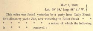
"When the record left at Point Yictory was opened to add thereto the supplemental information which gives it its chief value, Captain Fitzjames, as may be con- cluded by the colour of the ink, filled in the date — 28th — in May, when the record was originally deposited. The cylinder containing this record had not been soldered up again ; I suppose they had not the means of doing so ; it was found on the ground amongst a few loose stones which had evidently fallen along with it from the top of the cairn. Hobson removed every stone of this cairn down to the ground and rebuilt it."
However I still have not a clear idea if there are three or two cairns involved in this story. We should assume that Gore left the note in first place in Ross´s cairn, where it was taken by Irving. After the landing, as Franklin´s note says, Ross´s pillar wasn´t found and the paper was transfered to the pillar erected in the position where it should have been, which is Crozier´s landing cairn I guess...a different one from the Ross-VIctory cairn.
Then when McClintock talks about VIctory pount cairn he was actually talking about Crozier´s landing cairn, but what I don´t undestand is why Fitzjames says the paper was transfered to the "this position which is that in which Sir J. Ross' pillar was erected"?. WHat did he mean with that? From this I had always thought that Crozier´s and Ross´s cairns were the same, and that the one on which Gore left the note was another one north of Ross-Crozier´s. But I am surely wrong.
I have found later this Russell´s post about Louie Kamookak. On it, it appears Louie in Victory Point cairn commemorating the 150 th annyversary of Crozier´s landing . There is a plaque on the top (https://visionsnorth.blogspot.com/2018/03/louie-kamookak-1959-2018.html):
Andrés, thanks for this great post!
ResponderEliminarIt seems to me there are two question: 1) How many cairns (or pillars or whatever) were in fact built and by whom, 2) What Fitzjames and Crozier thought about cairns they found or looked for.
Concerning the latter: I now read again answers to my 5 years old question in RFE Facebook group about meaning of the word "pillar". Regina Koellner offers this interpretation of Victory Point message (my comments in square brackets -[]):
"Lt. Irving found the note four miles to the North in a cairn which was supposed [by Gore?] to be built by James Ross but probably wasn't (because it was Gore's cairn? [it cannot be the case if Gore thought it was Ross's cairn; but it could be built by Ross's men as Andrés suggests]). So the message was taken away from that spot and moved to a new cairn that was now built in the spot where James Ross's cairn/pillar should have been."
Anyway, I think it is extremely difficult to guess what Fitzjames and Crozier really knew / thought at the moment of writing their message. As many people pointed out, the found message could be just one of many (although I have some doubts about it).
E.g. McClintock in his book about "finding Franklin" gives wrong number - 135 - of Franklin's men lost in Arctic (apparently does not count men returned from Disco and Orkneys). And he certainly had better conditions to search information, think and write than officers at King Williams Island...
Hi Radek, it is a pleasure to read you here!
EliminarRegarding the number of men lost, in the Conclusions of the narrative of the voyage of the Fox, McCLintock stablish that the number of lost men was indeed 129. He mentions the amount of 138 and then give the names of the five ones who didn´t finally go.
Regarding the Victory point cairn, to me at least, this is still an open question. I think I will never have a clear idea if Fitzjames built a new cairn where he thought Ross´s pillar (or cairn) was supposed to have been built (why it wasn´t there is strange, a cairn can last 15 years perfectly well, specially in that part which wasn´t frequently visited). Same happens with Gore´s cairn, I think that Gore had correctly placed the note in the actual Ross´s cairn and that it is Fitzjames who was wrong for some unknown reason. Gore put his note on may 1847, maybe conditions then were more favourable than in april of the following year and simply Fitzjames couldn´t find Ross´s (and Gore) cairn under the snow and decided to build his own, then ... we would have twins :)!!
Hi Andrés, it is my pleasure to read your posts and kind replies! :-)
EliminarConcerning Clintock: you are absolutely right that he mentioned 138 men (135 was my mistake): "Another discrepancy exists in the second part of the record written by Fitzjames. The original number composing the expedition was 138 souls..." and only after return to England corrects himself: "I am now enabled to state ... that only one hundred and thirty-four individuals left the United Kingdom, and of these five men subsequently returned..." and gives names of those five returned men, as you mentioned.
But I just wanted to "complain" that any interpretation of the Victory Point paper is extremely difficult as we cannot know what is just a "normal" mistake (as my mistake in the previous comment), what is an error caused by some deteriorating health condition of the authors and what is correct and logical but we are missing some piece of information...
Your explanation of "Fitzjames's cairn" seems to me to correspond very well to the text. Just to summarize if I understand correctly: Gore found Ross's cairn in 1847. Fitzjames judged that the cairn found by Gore was built by Ross, but that this is not the pillar (tall cairn?), just some "usual" cairn built during Ross's journey.
And as Fitzjames did not find Ross's pillar at the "right" place, he just build his own "pillar" (cairn) – not because he wanted to "rebuild" (there was nothing to rebuild, in fact) Ross's one, but because he needed to his own message in it.
Unfortunately this theory (nor any other, I am afraid) does not explain why Fitzjames wasted so much paper for this story...
Andrés si te gustaron mis posts de Scott y de Franklin te dejo los de Shackleton:
ResponderEliminarhttp://playmoguardian.blogspot.com/2021/02/shackleton-el-desafio-de-la-antartida.html?m=1
Puedes seguir los demás en la etiqueta Antártida.
Saludos
Si, los he visto todos, me encantan. Me parece una gran idea y me imagino que te debes de divertir muchísimo haciendo las composiciones y las fotos.
EliminarYou can achieve your dreams by being a member of the Great ILLUMINATI brother hood. With this all your dreams and heart desire can be fully accomplish, if you really want to be a member of the great Illuminati brotherhood, Note: newly recruited members are entitled with 600,000 US Dollars , A Ring, that will protect and guild you from enemies, and a visa . Warning only contact us if you're interested. Kindly contact via whatsapp:+905488400195
ResponderEliminaremail: illuminatihood6666@hotmail.com