KABLOONAS

KABLOONAS
Burial of John Franklin. Author: me

KABLOONAS

Kabloonas is the way in which the Inuit who live in the north part of Canada call those who haven´t their same ascendency.

The first time i read this word was in the book "Fatal Passage" by Ken McGoogan, when, as the result of the conversations between John Rae and some inuit, and trying to find any evidence of the ill-fated Sir John Franklin Expedition, some of then mentioned that they watched how some kabloonas walked to die in the proximities of the river Great Fish.

I wish to publish this blog to order and share all those anecdotes that I´ve been finding in the arctic literature about arctic expeditions. My interest began more than 15 years ago reading a little book of my brother about north and south pole expeditions. I began reading almost all the bibliography about Antarctic expeditions and the superknown expeditions of Scott, Amundsen, Shackleton, etc. After I was captured by the Nansen, Nobile and Engineer Andree. But the most disturbing thing in that little book, full of pictures, was the two pages dedicated to the last Franklin expedition of the S.XIX, on that moment I thought that given the time on which this and others expeditions happened, few or any additional information could be obtained about it. I couldn´t imagine that after those two pages It would be a huge iceberg full of stories, unresolved misteries, anecdotes, etc. I believe that this iceberg, on the contrary than others, would continue growing instead melting.


miércoles, 5 de enero de 2022

VICTORY POINT CAIRN: THE SILENT WITNESS

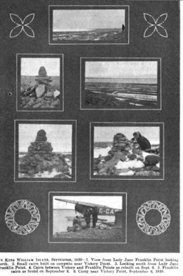
In the northwest coast of the now mythical King William island, not far from the northernmost corner of the triangle shape  wich it forms, a two meters high cairn was built the 29th may 1830 by James Clark Ross. That was the first time this island was visited by explorers. The next visitors would be Thomas Simpson and Warren Dease who, in 1839, would build another cairn in the south coast.

Ross, accompanied by some men and eight dogs, left on may 1830 their ship Victory in Felix Harbour to lead a sledge party which intention was to ascertain if there was any passage connecting Prince Regent Inlet with Point Turnagain. That was the furthest point reached by John Franklin in the north coast of the American continent during his expedition of 1819-21. 

The party crossed Boothia peninsula and the channel which separates it from King William Island, James Ross strait, to end landing in its northeast shore. They hadn´t found the navigable connection they were looking for, but had discovered a new piece of land in the very heart of the arctic archipielago.

Ross´s reflections, right after landing on the island which was destined to be remembered forever as the scenary of the biggest polar tragedy of all times, look to me somehow premonitory:

"No one will be surprised to hear how often during all these years we have formed the idle wish that men could live without food; a wish, idle and nonsensical as we felt it, that has ever intruding, since the necessity of eating was the ever-recurring obstacle to all our endeavours"

If these "idle and nonsensical" wishes had become true, Franklin´s expedition´s fate would have been a very different one. 

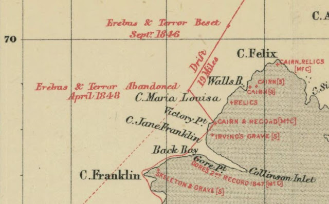
Once in these new land, they walked northwestward and reached Cape Felix, the northern tip of King William Island. From there, they carried out to the southwest following its shores. Ross was happy to see how now the coastline was leading him towards his target, Point Turnagain but Ross´s provisions were scarce. They were meant to last just twenty one days, a great contrast with the provisions carried by fututre parties which could travel for as long as three months, so the expedition had came to its end.

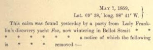
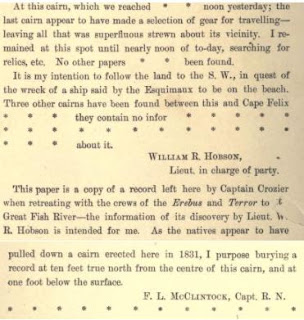
Thomas Abernethy and James Ross separated from the party and continued southward  some miles more till they decided to stop north of Back´s bay. This was the place where they decided to turn around and where they built the cairn which would become years after the recipient of the only (*) written message coming from the Franklin expedition. Ross describes the moment this way:

"We now therefore unfurled our flag for the usual ceremony, and took possession of what we saw as far as the distant point, while that on which we stood was named Victory point; being the " ne plus ultra " of our labour, as it afterwards proved, while it will remain a standing record of the exertions of that ship's crew. The point to the south-west was also named Cape Franklin: and if that be a name which has now been conferred on more places than one, these honours, not in fact very solid when so widely shared, are beyond all thought less than the merits of that oflicer deserve.

On Victory point we erected a cairn of stones six feet high, and we enclosed in it a canister containing a brief account of the proceedings of the expedition since its departure from England. Such has been the custom, and to that it was our business to conform ; though I must say, that we did not entertain the most remote hope that our little history would ever meet an European's eye, even had it escaped the accident of falling into the hands of the Esquimaux.

Yet we should have gone about our work with something like hope, if not confidence, had we then known that we were reputed as lost men, if even still alive, and that our ancient and tried friend Back was about to seek for us, and to restore us once more to society and home. And if it is not impossible that the course of his present investigations from Cape Turnagain east-ward may lead him to this very spot, that he may find the record and proof of our own "turnagain," we have known what it is for the wanderer in these solitudes to alight upon such traces of friends and of home, and can almost envy him the imagined happiness; while we shall rejoice to hear that he has done that in which we failed, and perhaps not less than if we had ourselves succeeded in completing this long pursued and perilous work."

The Victory point cairn was born. It was elegantly crowned with the Union Jack and stood proud looking defiantly to the icy waters which laid to its west. "More explorers will come to put an end to this war", it looked to be saying..., and they actually did, but to fight a hopeless battle instead.

As we have read above, Ross seemed to have some sort of prophetic powers. Apart from the aforementioned appropiated reflection about the ´so human´ necessity of food (specially in this barren lands), he named the farthest piece of land at sight as Cape Franklin. Apparently, after being christened, the cape started to intone an inaudible syren´s chant which attracted the Franklin expedition to its perdition. The crews from Erebus and Terror landed close to this point in april of 1848. Their target now wasn´t to continue the exploration, but to run towards safety in a desperate race to survive.

It would had been a coincidence that Franklin, who died in june of 1847, had been buried in the cape which bears his name. A coincidence similar to that of the watery grave, Terror bay, in which was found HMS Terror shipwreck not long time ago. But however prophetical Ross could be, he was wrong this time about the fate of the record he left in the cairn. He failed to foreseen that the paper he had left would be indeed taken by european hands seventeen years later in 1847, or at least that is what I think it should have happened.

It was by chance, while consulting the detailed map of John Ross narrative of his voyage of 1829-33, that I found this interesting drawing of  the landscape as it was seen from Victory point placed in the down left corner upside down.


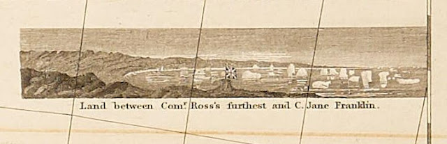
I am not completely sure if I had seen this before. The drawing sounds very familiar to me, but I can´t remember where or when I have seen this. The sight of the Union Jack waving happily at Victory point years before it would become the monument of a tragedy looks very dramatic to me. It was built to take possesion of a land and also to indicate from where future expeditions should resume the exploration of the Northwest passage but now it is only reminded as the bearer of bad news.

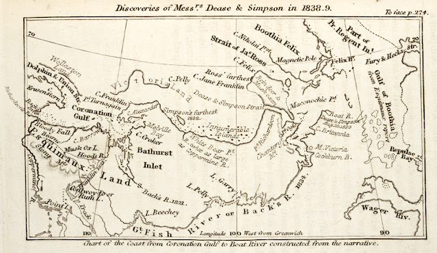
The next visitors to this region, Simpson and Dease, mentioned above, drew in the maps part of the south coast of the island and discovered the strait which separates the mainland from King William island.


They had linked the discoveries made by Franklin with the same land discovered by Ross, though they didn´t visit Ross furthest point. There were, therefore, blank spaces in the map still to explore. It was necessary to look for a passage which could link Barrow strait with this new waters discovered by Ross and Simpson. It would be the Franklin expedition which would fill those gaps during all the years they were locked in that region.

The Franklin expedition would be the first on arriving to Victory point after its discovery. They should have taken Ross´s note and interchanged it for their own one as it was the custom. That was the way those cairn were used for in the arctic regions by the explorers, as some sort of mailboxes, places to leave news and also to receive them. But that maybe didn´t happen that way.

The so called "Victory point record", contents an erratic description of the manipulation of the paper which is said to have been allegedly deposited for first time in Ross´s cairn. After being recovered by another sledge party, it was fulfilled with a much more pesimistic message and left in another cairn four miles southward from its original position. What the note says is the following:

"This paper was found by Lt. Irving under the cairn supposed to have been built by Sir James Ross in 1831—4 miles to the Northward—where it had been deposited by the late Commander Gore in May 1847. Sir James Ross' pillar has not however been found and the paper has been transferred to this position which is that in which Sir J. Ross' pillar was erected"

The last assertion makes ones hesitates if Graham Gore, the first on depositing the message, had actually found Ross´s cairn in Victory point or if he had put it under a different one northwards. Maybe, the men who James Ross have left behind when he decided to push a little bit forward, had built another cairn while they waited for his commander. This place was called Point Culgruff. 

The paper was left for second time in a different place, which was suppossed to be the actual location of Ross´s cairn, but from the note I have deduced that this latter no longer existed and had to be rebuilt. That could mean that the Franklin expedition didn´t get Ross´s note after all and it may be still there.

There, the informative paper, one of the only two, left by the expedition in the island, had to wait more than ten years before being discovered by McClintock´s expedition in 1859.


The northwest coast of the island was barely visited by the natives by that time. That Franklin´s note was untouched during that long period is a proof of that. However, Inuit presence wasn´t too far. Ross describes in his narrative that there were Inuit stone huts in the northeast coast and that there were also many remains of fishing camps and boats at the other side of the channel, in the west coast of Boothia peninsula.

Lieutenant Hobson, who accompanied McClintock in his searching expedition found the cairn and the note left by the Franklin expedition inside it. McClintock reached the cairn days after and demolished it in an unsuccesful attempt of finding any further clue, just to build it again to continue its life as a post office.

"Besides placing a copy of the record taken away by Hobson from the cairn, we both put records of our own in it ; and I also buried one under a large stone ten feet true north from it, stating the explorations and discoveries we had made."

It would take another long period before the cairn was visited again. Twenty years later, Frederick Schwatcka and William Gilder´s expedition, found it the 11th july 1879 and retrieved McClintock´s note. The cairn had again carried out its mission succesfuly. In Gilder´s words:

"It, however, proved to be a copy of the Crozier record found by Lieutenant Hobson, of McClintock's expedition, and was in the handwriting of Sir Leopold McClintock. The document was written with a lead pencil on note-paper, and was partially illegible from exposure. It was literally as follows :"


Gilder and Schwatcka tried to find the other record mentioned by McClintock following his instructions, but they never found it. In the narrative of their voyage, it is not mentioned if following the tradition, Schwatka had left any note under the cairn, so we may assume they didn´t.

There were others who visited the place many years after, like Burwash (1930), who in his report said that "No rock in place was found in the area", or Henry Larsen (1949), but, as far as I know the cairn at Victory point had by then disappeared. None of the cairns photographed by Burwash seems to be our Victory point cairn but others build towards Cape Jane Franklin:


So, it is likely that the Victory point cairn was destroyed years after Schwacka´s visit between 1879 and 1930, not reaching the age of one hundred years. However, it is strange that other cairns, like those found by Burwash, survived along all these years, and the more prominent Victory´s cairn didn´t.  

As far as I know, the cairn at Victory point no longer exists, I don´t think it has ever been rebuilt since then, though I may be wrong. On the other hand, it is interesting to remark that paradoxically, whereas the Victory point record is now perfectly safe and well preserved in England (as the fabulous blog by Logan Zachary showed us), Ross´s note has apparently dissappeared forever. I cannot but conjecture that the Franklin expedition actually could have taken it and that maybe now, the canister with Ross´s note, lays in a shelg inside the Erebus or the Terror waiting to be recovered.

This wasn´t intended to be the story of the Victory point record, that, was beautifully told by Russell Potter in this blog post. This was meant to be the history of a cairn, a story of hope in many senses. It was built with the intention of being a starting point, but it became instead the bottle which desperately pretended to convey the message about the whereabouts of the Franklin expedition castaways. It would have been surely confused, if he could have had thoughts at all, when it welcomed a promising Franklin expedition in 1847 only to observe powerless how a year after its one hundred remainder men landed in the nearby shores to start a desperate race towards tragedy, privations and death.

I really wish, nonsensically like Ross, that this silent witness could actually be able to talk to tell us what happened there. Maybe we should rebuild it again, sit in front, and then ask.

(*) There were in fact other written records, but the one found in Victory point was the one which gave more information.